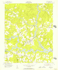
1954 Map of Dendron
USGS Topo · Published 1957About this map
Dendron serves as the central hub of this mid-century survey, situated at a junction of roads in the heart of southeastern Virginia. The landscape is defined by the complex, branching waterways of the Blackwater River and its numerous tributaries, including Cypress Swamp, Hazel Swamp, and Johnny Hawkins Swamp. This network of wetlands and low-lying ground shaped the local community, as seen in the placement of landmarks like Spratleys Mill and river crossings such as Walls Bridge and Birched Island Bridge.
Find a feature on this map
32 named features on this map. Tap any name to fly to it.
Don’t see what you’re looking for? This feature index may not catch every label — zoom into the map to look around manually.
Map Details
Editions of this 1954 Dendron Map
This is the sole edition of this map. No revisions or reprints were ever made.
Other maps of this area

1919 · Surry
USGS Topo · 1:62,500

1919 · Disputanta
USGS Topo · 1:62,500

1919 · Homeville
USGS Topo · 1:48,000

1920 · Ivor
USGS Topo · 1:62,500

1920 · Homeville
USGS Topo · 1:62,500

1943 · Manry
USGS Topo · 1:31,680

1943 · Savedge
USGS Topo · 1:31,680

1943 · Richmond
USGS Topo · 1:250,000

1944 · Waverly
USGS Topo · 1:31,680

1944 · Ivor
USGS Topo · 1:24,000