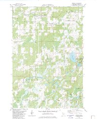
1982 Map of Denham
USGS Topo · Published 1982About this map
Denham and the southern edge of Sturgeon Lake anchor this 1982 survey of Pine County, Minnesota. The landscape is defined by the water networks of the Kettle River and Birch Creek, alongside numerous smaller water bodies such as Fox Lake, Mud Lake, and Cemetery Lake. Transportation history is visible in the alignment of the Soo Line and an Old Railroad Grade that cuts through the forested terrain. This era shows a community centered on its local history, with three distinct burial grounds—Denham Cem, Lakeview Cem, and Faith Cem—placed near the small settlements of Denham and Rutledge. The presence of the Mark State Wildlife Management Area in the east suggests a transition toward conservation and managed natural space, while scattered Gravel Pits and a Sandpit indicate local industry during this period.
Find a feature on this map
25 named features on this map. Tap any name to fly to it.
Don’t see what you’re looking for? This feature index may not catch every label — zoom into the map to look around manually.
Map Details
Editions of this 1982 Denham Map
This is the sole edition of this map. No revisions or reprints were ever made.
Other maps of this area

1953 · Duluth
USGS Topo · 1:250,000

1958 · Duluth
USGS Topo · 1:250,000

1961 · Sandstone
USGS Topo · 1:62,500

1961 · Moose Lake
USGS Topo · 1:62,500

1968 · Giese
USGS Topo · 1:24,000

1969 · Arthyde
USGS Topo · 1:24,000

1969 · Ronald
USGS Topo · 1:24,000

1980 · Sandstone
USGS Topo · 1:100,000

1981 · Willow River
USGS Topo · 1:24,000

1981 · Kettle River
USGS Topo · 1:24,000