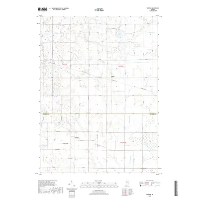
2019 Map of Denham
USGS Topo · Published 2019About this map
Aldine and Denham anchor this rural landscape along the border of Starke and Pulaski counties, revealing a region defined by an extensive, engineered network of water management. The terrain is crisscrossed by numerous named drainage features, including Cedar Lake Ditch, Craigmile Ditch, and Quigley Marsh Ditch, which speak to the historic reclamation of wetlands for agricultural use. This drainage system reaches toward Round Lake in the north and follows natural watercourses like Bogus Run.
Find a feature on this map
58 named features on this map. Tap any name to fly to it.
Don’t see what you’re looking for? This feature index may not catch every label — zoom into the map to look around manually.
Map Details
Editions of this 2019 Denham Map
This is the sole edition of this map. No revisions or reprints were ever made.
Other maps of this area

1953 · Chicago
USGS Topo · 1:250,000

1957 · Chicago
USGS Topo · 1:250,000

1957 · Knox East
USGS Topo · 1:24,000

1957 · Knox West
USGS Topo · 1:24,000

1959 · English Lake
USGS Topo · 1:24,000

1959 · North Judson
USGS Topo · 1:24,000

1962 · Winamac
USGS Topo · 1:24,000

1962 · Denham
USGS Topo · 1:24,000
1962 · Ripley
USGS Topo · 1:24,000

1962 · Bass Lake
USGS Topo · 1:24,000