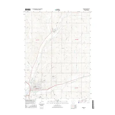
2015 Map of Denison
USGS Topo · Published 2015About this map
The Boyer River and East Boyer River converge in this western Iowa landscape, shaping the development of Denison and the nearby village of Deloit. The 2015 topography reveals a community structured around these waterways and the associated drainage of Otter Cr, Buffalo Cr, and Walnut Cr. For those tracing local heritage, the map identifies several significant burial sites, including Saint Rose of Lima Cem, Old Catholic Cem, and the Milford Cem north of town. The presence of Donna Reed RD honors the town's connection to its most famous native daughter, while the Yellow Smoke Park Bridge serves as a modern landmark. The terrain outside the river valleys is marked by the distinct ridge-and-run patterns of Rocky Run, showing the transition from agricultural land to the structured urban grid of central Denison.
Find a feature on this map
94 named features on this map. Tap any name to fly to it.
Don’t see what you’re looking for? This feature index may not catch every label — zoom into the map to look around manually.
Map Details
Editions of this 2015 Denison Map
This is the sole edition of this map. No revisions or reprints were ever made.
Other maps of this area

1954 · Omaha
USGS Topo · 1:250,000

1954 · Fort Dodge
USGS Topo · 1:250,000

1957 · Omaha
USGS Topo · 1:250,000

1957 · Fort Dodge
USGS Topo · 1:250,000

1958 · Omaha
USGS Topo · 1:250,000

1958 · Fort Dodge
USGS Topo · 1:250,000

1971 · Schleswig
USGS Topo · 1:24,000

1971 · Earling NE
USGS Topo · 1:24,000

1971 · Denison
USGS Topo · 1:24,000
1971 · Dow City
USGS Topo · 1:24,000