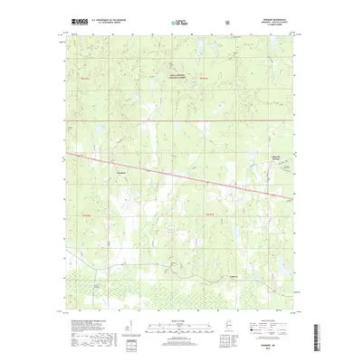
2018 Map of Denmark
USGS Topo · Published 2018About this map
The Yocona River bottomlands define the southern edge of this Lafayette County landscape, where the river meets Sinton Cr and Sandy Cr near the crossing at Price Bridge. To the north, the terrain transitions into the wooded uplands of the Holly Springs National Forest, characterized by numerous stream valleys including Kettle Cr and Jones Cr. Local history is anchored by the small communities of Denmark, Lafayette Springs, and Dogtown, which remain connected by a network of county roads. Genealogists will find a wealth of family history sites across the township lines, including Lafayette Springs Cem, Springdale Cem, and the high ground at Liberty Hill. The presence of several small water bodies, such as Denmark Lake and Midway Lake, suggests the local agricultural and recreational character of the area during the late twenty-first century.
Find a feature on this map
64 named features on this map. Tap any name to fly to it.
Don’t see what you’re looking for? This feature index may not catch every label — zoom into the map to look around manually.
Map Details
Editions of this 2018 Denmark Map
This is the sole edition of this map. No revisions or reprints were ever made.
Other maps of this area

1942 · Denmark
USGS Topo · 1:62,500

1943 · Denmark
USGS Topo · 1:62,500

1949 · New Albany
USGS Topo · 1:62,500

1951 · New Albany
USGS Topo · 1:62,500

1956 · Tupelo
USGS Topo · 1:250,000

1958 · Tupelo
USGS Topo · 1:250,000

1972 · Paris
USGS Topo · 1:24,000

1972 · Randolph
USGS Topo · 1:24,000
1972 · Tula
USGS Topo · 1:24,000
1980 · Thaxton
USGS Topo · 1:24,000