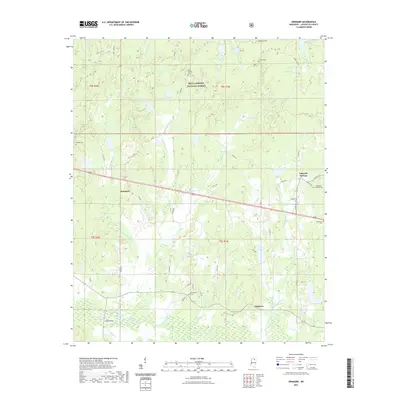
2021 Map of Denmark
USGS Topo · Published 2021About this map
The Holly Springs National Forest encompasses much of this Lafayette County landscape, where the northern drainages of Puskus Cr and W Cypress Cr meet the southern reaches of the Yocona River. This modern survey reveals a region defined by its small crossroads settlements and numerous rural burying grounds. Denmark sits at a central junction, while Lafayette Springs and Dogtown anchor the eastern and southern portions of the quadrangle. Local genealogy is well-represented through several legacy burial sites, including the Lafayette Springs Cem, Spring Hill Cem, and the secluded Bluff Springs Cem. Water features such as Denmark Lake and Dewberry Lake are interspersed among a network of county roads, while the Price Bridge provides a key crossing over the river bottomlands near the southern boundary.
Find a feature on this map
62 named features on this map. Tap any name to fly to it.
Don’t see what you’re looking for? This feature index may not catch every label — zoom into the map to look around manually.
Map Details
Editions of this 2021 Denmark Map
This is the sole edition of this map. No revisions or reprints were ever made.
Other maps of this area

1942 · Denmark
USGS Topo · 1:62,500

1943 · Denmark
USGS Topo · 1:62,500

1949 · New Albany
USGS Topo · 1:62,500

1951 · New Albany
USGS Topo · 1:62,500

1956 · Tupelo
USGS Topo · 1:250,000

1958 · Tupelo
USGS Topo · 1:250,000

1972 · Paris
USGS Topo · 1:24,000

1972 · Randolph
USGS Topo · 1:24,000
1972 · Tula
USGS Topo · 1:24,000
1980 · Thaxton
USGS Topo · 1:24,000