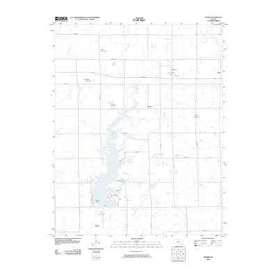
2010 Map of Dennis
USGS Topo · Published 2010About this map
Big Hill Lake dominates the central landscape of this Labette County region, formed by the Big Hill Dam to manage the waters of Big Hill Creek. This modern survey reveals a countryside where the rural grid of the Kansas prairie meets significant topographical shifts, most notably at Twin Mounds and Bender Mounds. The small community of Dennis sits at the intersection of Us HWY 400 and Finney Rd, serving as a central point for the surrounding agricultural network. Local history is anchored by Harmony Cemetery and Pleasant Hill Cemetery, which offer clues to the early families who settled near Grove and Fern. Transport is marked by the presence of Big Hill Siding and a complex system of parkways, such as Cherryvale Pkwy and Mound Valley Pkwy, that facilitate access to the recreational and utility areas surrounding the reservoir.
Find a feature on this map
37 named features on this map. Tap any name to fly to it.
Don’t see what you’re looking for? This feature index may not catch every label — zoom into the map to look around manually.
Map Details
Editions of this 2010 Dennis Map
This is the sole edition of this map. No revisions or reprints were ever made.
Other maps of this area

1886 · Independence
USGS Topo · 1:125,000

1886 · Parsons
USGS Topo · 1:125,000

1893 · Parsons
USGS Topo · 1:125,000

1894 · Independence
USGS Topo · 1:125,000

1905 · Independence
USGS Topo · 1:125,000

1945 · Parsons
USGS Topo · 1:62,500

1946 · Parsons
USGS Topo · 1:62,500

1946 · Mound Valley
USGS Topo · 1:62,500

1947 · Parsons
USGS Topo · 1:62,500

1947 · Joplin
USGS Topo · 1:250,000