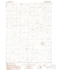
1989 Map of Dennison Cap
USGS Topo · Published 1989About this map
Siberia Ridge dominates the northern landscape of this Sweetwater County quadrangle, a high-desert expanse characterized by remote sheep camps and intermittent water sources. Based on field work from the late 1950s and mid-1980s, the map reveals a land utilized for grazing and energy extraction. Seasonal watering spots like Twelvemile Hole and Black Lake provide critical landmarks in a region largely defined by its topography, such as the prominent Dennison Cap. The infrastructure consists primarily of unimproved paths and industrial corridors, including a pipeline and the Luman Ranch Road. Remote outposts such as Buzzard Sheep Camp and Circle Bar Sheep Camp suggest the enduring importance of livestock ranching in this isolated portion of Wyoming, while scattered Gas Wells reflect the area's development for natural resources during the latter half of the 20th century.
Find a feature on this map
11 named features on this map. Tap any name to fly to it.
Don’t see what you’re looking for? This feature index may not catch every label — zoom into the map to look around manually.
Map Details
Editions of this 1989 Dennison Cap Map
This is the sole edition of this map. No revisions or reprints were ever made.
Other maps of this area

1954 · Rawlins
USGS Topo · 1:250,000

1954 · Rock Springs
USGS Topo · 1:250,000

1958 · Rawlins
USGS Topo · 1:250,000

1958 · Rock Springs
USGS Topo · 1:250,000

1960 · Lost Creek Butte
USGS Topo · 1:62,500

1960 · Hansen Lake
USGS Topo · 1:24,000

1962 · Rawlins
USGS Topo · 1:250,000

1962 · Rock Springs
USGS Topo · 1:250,000

1966 · Wamsutter
USGS Topo · 1:24,000

1966 · Monument Lake
USGS Topo · 1:24,000