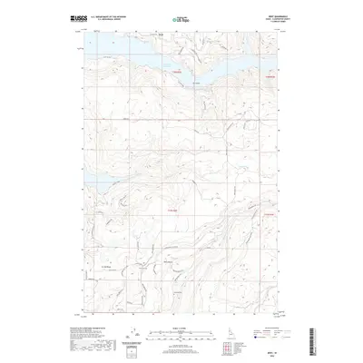
2020 Map of Dent
USGS Topo · Published 2020About this map
Dworshak Reservoir dominates the northern landscape of this Clearwater County region, where the steep, timbered drainages of Canyon Creek and Whiskey Creek flow toward the water. The map documents a rugged rural interior characterized by isolated settlements like Dent and Wells Bench, connected by winding routes such as Dent Bridge Road and Grangemont Road. Genealogists will find particular value in the documentation of family-named landmarks and local burial sites, including Wells Cemetery and Weseman Cemetery. High-elevation points like Eureka Ridge and Huckleberry Butte define the topography, illustrating the transition from deep creek beds to prominent overlooks. The network of modern local roads, including colorfully named paths like Grumpy Old Men Road and Broken Spokes Lane, reveals the contemporary residential and recreational footprint within this remote Idaho terrain.
Find a feature on this map
89 named features on this map. Tap any name to fly to it.
Don’t see what you’re looking for? This feature index may not catch every label — zoom into the map to look around manually.
Map Details
Editions of this 2020 Dent Map
This is the sole edition of this map. No revisions or reprints were ever made.
Other maps of this area

1924 · Kamiah
USGS Topo · 1:125,000

1955 · Pullman
USGS Topo · 1:250,000

1958 · Pullman
USGS Topo · 1:250,000

1961 · Ahsahka
USGS Topo · 1:62,500

1967 · Rudo
USGS Topo · 1:24,000

1967 · Orofino West
USGS Topo · 1:24,000

1967 · Orofino East
USGS Topo · 1:24,000

1969 · Elk Creek Falls
USGS Topo · 1:24,000
1969 · Grangemont
USGS Topo · 1:24,000
1969 · Dent
USGS Topo · 1:24,000