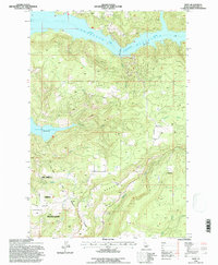
1994 Map of Dent
USGS Topo · Published 1997About this map
Dworshak Reservoir dominates this landscape in Clearwater County, where the rising waters of the North Fork Clearwater River transformed the local geography. The map captures the interface between managed timberlands and the northern reaches of the Nez Perce Indian Reservation, which occupies the southwestern corner of the sheet. Settlement patterns are concentrated on the higher ground of Wells and Eureka Ridge, featuring several localized family landmarks and community sites. Small, scattered locales like Dent, Best Corner, and Hansberg provide specific points of reference for local historians. Notable for genealogical researchers are the Wells Cem and Weseman Cem, which remain as markers of the area's rural heritage. The infrastructure of the era is anchored by the Dent Bridge, crossing the reservoir's expanse to connect these isolated ridgeline communities.
Find a feature on this map
20 named features on this map. Tap any name to fly to it.
Don’t see what you’re looking for? This feature index may not catch every label — zoom into the map to look around manually.
Map Details
Editions of this 1994 Dent Map
This is the sole edition of this map. No revisions or reprints were ever made.
Other maps of this area

1924 · Kamiah
USGS Topo · 1:125,000

1955 · Pullman
USGS Topo · 1:250,000

1958 · Pullman
USGS Topo · 1:250,000

1961 · Ahsahka
USGS Topo · 1:62,500

1967 · Rudo
USGS Topo · 1:24,000

1967 · Orofino West
USGS Topo · 1:24,000

1967 · Orofino East
USGS Topo · 1:24,000

1969 · Elk Creek Falls
USGS Topo · 1:24,000
1969 · Grangemont
USGS Topo · 1:24,000
1969 · Dent
USGS Topo · 1:24,000