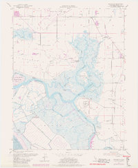
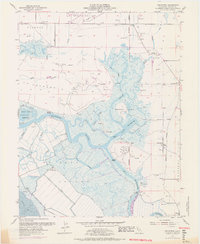
1953 Map of Denverton
USGS Topo · Published 1981About this map
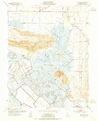
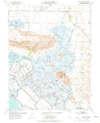
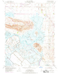
Nurse Slough and Denverton Slough wind through a complex system of marshes and islands in this mid-century survey of the California Delta. The landscape is defined by the transition from the rolling Montezuma Hills and Potrero Hills down into the tidal reaches of Grizzly Island and Bradmoor Island. Human infrastructure is closely tied to these waterways, with sites like Meins Landing, Lingos Landing, and Beldons Landing marking the historical importance of river transport.
Find a feature on this map
46 named features on this map. Tap any name to fly to it.
Don’t see what you’re looking for? This feature index may not catch every label — zoom into the map to look around manually.
Map Details
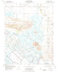
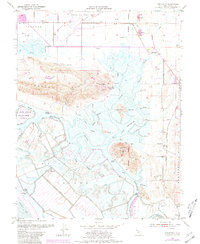
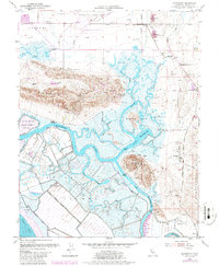
Editions of this 1953 Denverton Map
9 editions found
Historical Maps of Fairfield Through Time
74 maps found

1896 Carquinez Strait
Solano County, CA

1898 Karquines
Solano County, CA

1901 Carquinez
Solano County, CA

1916 Cache Slough
Solano County, CA

1916 Maine Prairie
Solano County, CA

1916 Saxon
Solano County, CA

1917 Wolfskill
Solano County, CA

1918 Birds Landing
Solano County, CA

1918 Collinsville
Solano County, CA

1918 Denverton
Solano County, CA

1918 Honker Bay
Solano County, CA

1921 Mt. Vaca
Solano County, CA

1940 Carquinez Strait
Solano County, CA

1942 Carquinez
Solano County, CA

1942 Mt. Vaca
Solano County, CA

1949 Fairfield South
Solano County, CA

1951 Cordelia
Solano County, CA

1951 Fairfield North
Solano County, CA

1951 Mt. Vaca
Solano County, CA

1951 Mt. Vaca
Solano County, CA

1952 Dozier
Solano County, CA

1952 Liberty Island
Solano County, CA

1952 Saxon
Solano County, CA

1953 Antioch North
Solano County, CA

1953 Birds Landing
Solano County, CA

1953 Denverton
Solano County, CA

1953 Honker Bay
Solano County, CA

1978 Antioch North
Solano County, CA

1978 Liberty Island
Solano County, CA

1980 Denverton
Solano County, CA

2012 Antioch North
Solano County, CA

2012 Birds Landing
Solano County, CA

2012 Cordelia
Solano County, CA

2012 Denverton
Solano County, CA

2012 Dozier
Solano County, CA

2012 Fairfield North
Solano County, CA

2012 Fairfield South
Solano County, CA

2012 Honker Bay
Solano County, CA

2012 Liberty Island
Solano County, CA

2012 Mount Vaca
Solano County, CA

2012 Saxon
Solano County, CA

2015 Antioch North
Solano County, CA

2015 Birds Landing
Solano County, CA

2015 Cordelia
Solano County, CA

2015 Denverton
Solano County, CA

2015 Dozier
Solano County, CA

2015 Fairfield North
Solano County, CA

2015 Fairfield South
Solano County, CA

2015 Honker Bay
Solano County, CA

2015 Liberty Island
Solano County, CA

2015 Mount Vaca
Solano County, CA

2015 Saxon
Solano County, CA

2018 Antioch North
Solano County, CA

2018 Birds Landing
Solano County, CA

2018 Cordelia
Solano County, CA

2018 Denverton
Solano County, CA

2018 Dozier
Solano County, CA

2018 Fairfield North
Solano County, CA

2018 Fairfield South
Solano County, CA

2018 Honker Bay
Solano County, CA

2018 Liberty Island
Solano County, CA

2018 Mount Vaca
Solano County, CA

2018 Saxon
Solano County, CA

2021 Antioch North
Solano County, CA

2021 Denverton
Solano County, CA

2021 Fairfield North
Solano County, CA

2021 Mount Vaca
Solano County, CA

2022 Birds Landing
Solano County, CA

2022 Cordelia
Solano County, CA

2022 Dozier
Solano County, CA

2022 Fairfield South
Solano County, CA

2022 Honker Bay
Solano County, CA

2022 Liberty Island
Solano County, CA

2022 Saxon
Solano County, CA