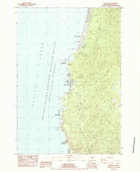
1984 Map of Depoe Bay
USGS Topo · Published 1984About this map
The rocky Lincoln County coastline is meticulously documented here, showing the development of Depoe Bay and Lincoln Beach during the early 1980s. This survey illustrates the intricate relationship between the coastal settlements and the geography of the Pacific Ocean front, where numerous waysides like Boiler Bay State Wayside and Otter Crest State Wayside line the Oregon Coast Highway. Significant landmarks such as Cape Foulweather, Spouting Horn, and Bald Government Point define the shore, while the interior is marked by the steep rise of Siletz Hill and the winding Siletz River. The infrastructure supporting the local community is evident in the presence of a Schoolhouse, a Sub Station, and the Depoe Bay Reservoir. Additionally, the map identifies the Oregon Islands National Wildlife Refuge Wilderness, underscoring the conservation of the numerous offshore rocks including Gull Rock and Rabbit Rock.
Find a feature on this map
41 named features on this map. Tap any name to fly to it.
Don’t see what you’re looking for? This feature index may not catch every label — zoom into the map to look around manually.
Map Details
Editions of this 1984 Depoe Bay Map
2 editions found
Other maps of this area

1941 · Cape Foulweather
USGS Topo · 1:62,500

1942 · Euchre Mtn
USGS Topo · 1:62,500

1942 · Yaquina
USGS Topo · 1:62,500

1942 · Toledo
USGS Topo · 1:62,500

1943 · Euchre Mtn
USGS Topo · 1:62,500

1944 · Cape Foulweather
USGS Topo · 1:62,500

1953 · Salem
USGS Topo · 1:250,000

1954 · Salem
USGS Topo · 1:250,000

1957 · Cape Foulweather
USGS Topo · 1:62,500

1957 · Yaquina
USGS Topo · 1:62,500