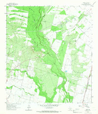
1964 Map of Derby
USGS Topo · Published 1966About this map
Derby serves as a primary settlement point in this mid-1960s landscape, situated along the Missouri Pacific railroad line near the eastern edge of the map. The terrain is defined by a dense network of watercourses, including the Frio River, Leona River, and Live Oak Creek, which converge and wind through the center of the sheet. The economy of the era is clearly visible through numerous Gravel Pits and an active Oil Field, linked by a prominent Pipeline.
Find a feature on this map
30 named features on this map. Tap any name to fly to it.
Don’t see what you’re looking for? This feature index may not catch every label — zoom into the map to look around manually.
Map Details
Editions of this 1964 Derby Map
2 editions found
Other maps of this area

1925 · Pearsall 1-b
USGS Topo · 1:48,000

1925 · Pearsall 1-c
USGS Topo · 1:48,000

1927 · Pearsall
USGS Topo · 1:62,500

1942 · Divot
USGS Topo · 1:62,500

1942 · Dilley
USGS Topo · 1:62,500

1953 · Crystal City
USGS Topo · 1:250,000

1955 · Crystal City
USGS Topo · 1:250,000

1956 · Woodward
USGS Topo · 1:62,500

1956 · Divot
USGS Topo · 1:62,500

1961 · Crystal City
USGS Topo · 1:250,000