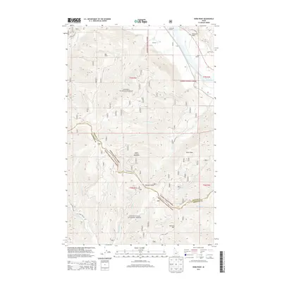
2013 Map of Derr Point
USGS Topo · Published 2013About this map
The Coeur d'Alene Mountains and the southern reaches of the Kanisku National Forest dominate this 2013 survey of the Idaho panhandle. The terrain is defined by a series of prominent peaks and ridgelines, including Whitetail Peak, Delyle Ridge, and the namesake Derr Point. To the south, the N Fork Coeur d'Alene River winds through the drainage below Summit Camp, while the Clark Fork flows near the eastern margin. Human presence is concentrated along the northern and southern road corridors, where CX Ranch and the Riverlake Airport sit near the confluence of the Clark Fork and McQuade Gulch. The map meticulously details the intersection of Bonner and Shoshone counties, capturing a landscape where forest management and remote outposts like Tuka Airport meet the hydrological network of Delyle Creek and Dahlman Creek.
Find a feature on this map
33 named features on this map. Tap any name to fly to it.
Don’t see what you’re looking for? This feature index may not catch every label — zoom into the map to look around manually.
Map Details
Editions of this 2013 Derr Point Map
This is the sole edition of this map. No revisions or reprints were ever made.
Other maps of this area

1909 · Cataldo
USGS Topo · 1:125,000

1911 · Cataldo
USGS Topo · 1:125,000

1911 · Priest Lake
USGS Topo · 1:250,000

1913 · Priest Lake
USGS Topo · 1:250,000

1949 · Packsaddle Mtn
USGS Topo · 1:62,500

1951 · Packsaddle Mtn
USGS Topo · 1:62,500

1951 · Clark Fork
USGS Topo · 1:62,500

1955 · Spokane
USGS Topo · 1:250,000

1958 · Spokane
USGS Topo · 1:250,000

1958 · Sandpoint
USGS Topo · 1:250,000