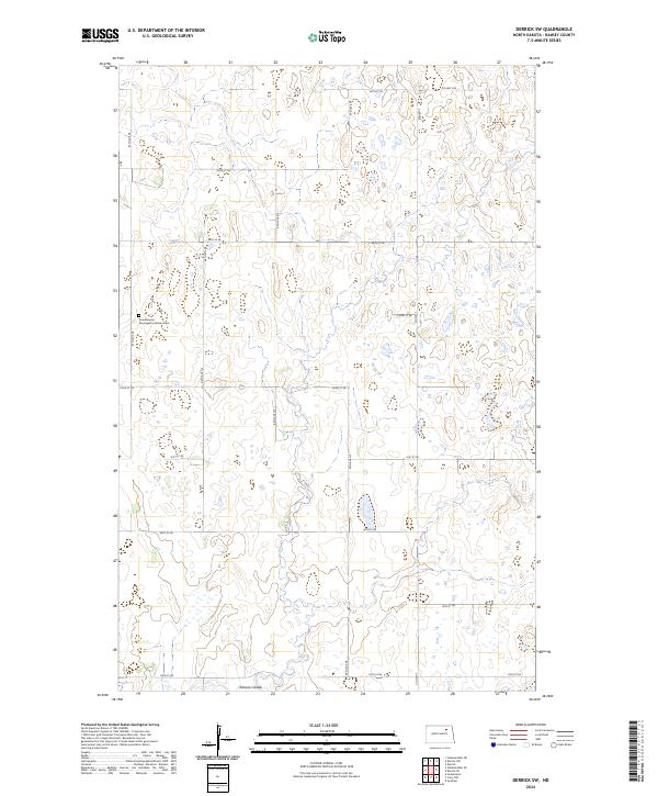
2024 Map of Derrick SW
USGS Topo · Published 2024About this map
The Scandinavian Norwegian Lutheran Cem serves as a prominent cultural landmark in this section of Ramsey County, reflecting the ethnic heritage of the northern plains. This portion of the landscape is defined by the winding path of Edmore Coulee as it meanders through a prairie terrain characterized by numerous small wetlands and glacial potholes. The map reveals a strictly regulated township-and-range survey system, with a dense grid of section roads like 87th Ave NE and 66th St NE providing access to the agricultural parcels. Major regional routes including Co Hwy 22A and Co Hwy 3 facilitate transportation across the county, connecting the remote farmsteads and rural cemeteries to larger hubs outside the immediate area.
Find a feature on this map
23 named features on this map. Tap any name to fly to it.
Don’t see what you’re looking for? This feature index may not catch every label — zoom into the map to look around manually.
Map Details
Editions of this 2024 Derrick SW Map
This is the sole edition of this map. No revisions or reprints were ever made.
Other maps of this area

1931 · Devils Lake
USGS Topo · 1:62,500

1950 · Devils Lake
USGS Topo · 1:62,500

1951 · Sweetwater
USGS Topo · 1:24,000

1953 · Devils Lake
USGS Topo · 1:250,000

1956 · Devils Lake
USGS Topo · 1:250,000

1957 · Starkweather SE
USGS Topo · 1:24,000

1962 · Starkweather NE
USGS Topo · 1:24,000

1971 · Southam
USGS Topo · 1:24,000
1971 · Crary NW
USGS Topo · 1:24,000

1972 · Derrick NW
USGS Topo · 1:24,000