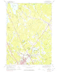
1968 Map of Derry
USGS Topo · Published 1978About this map
Derry and its surrounding villages served as a central hub of southern New Hampshire life in the late 1960s, showing a landscape defined by historic educational institutions and a shifting transport network. Pinkerton Academy and White Pines College anchor the residential developments of Derry Village and East Derry, while the Boston and Maine Railroad still traces its route through the heart of the community. The topography is marked by significant water bodies such as Massabesic Lake in the northwest and Beaver Lake near the town center, surrounded by numerous family-named peaks like Warner Hill and Bell Hill.
Find a feature on this map
97 named features on this map. Tap any name to fly to it.
Don’t see what you’re looking for? This feature index may not catch every label — zoom into the map to look around manually.
Map Details
Editions of this 1968 Derry Map
3 editions found
Other maps of this area

1888 · Haverhill
USGS Topo · 1:62,500

1890 · Haverhill
USGS Topo · 1:62,500

1893 · Haverhill
USGS Topo · 1:62,500

1905 · Manchester
USGS Topo · 1:62,500

1917 · Mt. Pawtuckaway
USGS Topo · 1:62,500

1919 · Mt. Pawtuckaway
USGS Topo · 1:62,500

1921 · Suncook
USGS Topo · 1:62,500

1935 · Haverhill
USGS Topo · 1:62,500

1939 · Mt. Pawtuckaway
USGS Topo · 1:62,500

1941 · Manchester
USGS Topo · 1:62,500