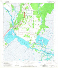
1967 Map of Des Allemands
USGS Topo · Published 1968About this map
Bayou Des Allemands flows through this low-lying landscape, marking the boundary between St Charles and Lafourche parishes. This 1967 survey depicts a region where water and industry are inextricably linked, with the Paradis Oil and Gas Field dominating the central terrain. The settlement of Des Allemands is situated at the convergence of the Southern Pacific Railroad and the bayou, serving as a primary hub for the local community.
Find a feature on this map
38 named features on this map. Tap any name to fly to it.
Don’t see what you’re looking for? This feature index may not catch every label — zoom into the map to look around manually.
Map Details
Editions of this 1967 Des Allemands Map
4 editions found
Other maps of this area

1891 · Hahnville
USGS Topo · 1:62,500

1892 · Lac Des Allemands
USGS Topo · 1:62,500

1892 · Cut-Off
USGS Topo · 1:62,500

1892 · Houma
USGS Topo · 1:62,500

1932 · Lac Des Allemands SE
USGS Topo · 1:31,680

1932 · Houma NE
USGS Topo · 1:31,680

1932 · Hahnville NW
USGS Topo · 1:31,680

1932 · Lac Des Allemands NE
USGS Topo · 1:31,680

1932 · Hahnville SW
USGS Topo · 1:31,680

1932 · Hahnville NE
USGS Topo · 1:31,680