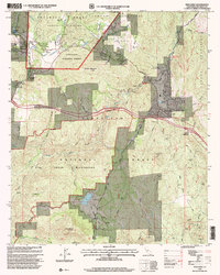
1997 Map of Descanso
USGS Topo · Published 2000About this map
Cleveland National Forest and the Pine Creek Wilderness dominate this high-country landscape, where small mountain settlements are connected by the path of Old Highway 80. The community of Descanso serves as a focal point near the Sweetwater River, supported by the Descanso Fire Station and Work Center and nearby Hulburd Grove. The map records a transition from organized recreation at the Rine Creek Bible Conference Ground to the remote terrain of the Cuyamaca Mountains. Water management is evident through the Gaging Station on Descanso Creek and the presence of Corte Madera Lake to the south. Local transit and utilities are marked by landmarks such as Laguna Junction and a Communication Tower, while a small Cem remains near the heart of the Descanso settlement, anchoring the area's local history.
Find a feature on this map
44 named features on this map. Tap any name to fly to it.
Don’t see what you’re looking for? This feature index may not catch every label — zoom into the map to look around manually.
Map Details
Editions of this 1997 Descanso Map
This is the sole edition of this map. No revisions or reprints were ever made.
Other maps of this area

1903 · Cuyamaca
USGS Topo · 1:125,000

1904 · Southern California Sheet No. 2
USGS Topo · 1:250,000

1931 · Carrizo
USGS Topo · 1:125,000

1939 · Campo
USGS Topo · 1:62,500

1942 · Potrero
USGS Topo · 1:48,000

1942 · Campo
USGS Topo · 1:62,500

1942 · Cuyapaipe
USGS Topo · 1:62,500

1942 · Cuyamaca Peak
USGS Topo · 1:62,500

1944 · Potrero
USGS Topo · 1:62,500

1944 · Cuyamaca Peak
USGS Topo · 1:62,500