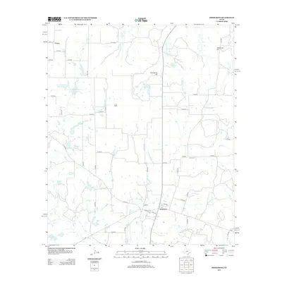
2012 Map of Desdemona
USGS Topo · Published 2012About this map
Chaney and Desdemona anchor this landscape in Eastland County, where the terrain transitions from the basin of the Leon River toward the elevated reaches of Mockingbird Hill and Rattlesnake Mtn. This 2012 survey illustrates a region defined by its hydrology and rural road network, notably the convergence of Ranch Road 8 and FM-2214. Numerous small water bodies like Holland Lake, Arnold Lake, and the specifically named Love and Rodgers Lake Number 3 indicate a history of local land management and stock ponds. For genealogists, the inclusion of Howard Cem near Hog Cr provides a vital touchstone for local family history research. The map captures the enduring agricultural character of the area, traced through a complex grid of county roads that navigate the tributaries of the S Fork Palo Pinto Cr.
Find a feature on this map
51 named features on this map. Tap any name to fly to it.
Don’t see what you’re looking for? This feature index may not catch every label — zoom into the map to look around manually.
Map Details
Editions of this 2012 Desdemona Map
This is the sole edition of this map. No revisions or reprints were ever made.
Other maps of this area

1890 · Stephenville
USGS Topo · 1:125,000

1894 · Eastland
USGS Topo · 1:125,000

1920 · Stephenville
USGS Topo · 1:125,000

1954 · Abilene
USGS Topo · 1:250,000

1958 · Abilene
USGS Topo · 1:250,000

1965 · Huckabay SW
USGS Topo · 1:24,000

1965 · Lingleville
USGS Topo · 1:24,000
1965 · Reddy Mountain
USGS Topo · 1:24,000

1966 · Kokomo
USGS Topo · 1:24,000
1966 · Desdemona
USGS Topo · 1:24,000