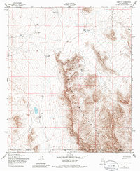
1955 Map of Desert NE
USGS Topo · Published 1986About this map
The Hueco Mountains dominate this arid landscape along the border of Otero and El Paso counties during the mid-1950s. This survey records a remote terrain where water management was critical for ranching or survival, as evidenced by a series of named catchments including Chaparral Tank, Flat Tank, and Coyote Tank. The presence of an Landing Strip (Aband) and scattered Oil Well symbols suggests earlier industrial or aviation activity that had already begun to recede by the time of the field annotation. Evidence of older habitation persists in the form of Ruins found near the mountain slopes, offering a glimpse into the transient nature of settlement in this high-desert environment. The map effectively captures the transition from historic land use to the mid-century infrastructure of southern New Mexico and west Texas.
Find a feature on this map
9 named features on this map. Tap any name to fly to it.
Don’t see what you’re looking for? This feature index may not catch every label — zoom into the map to look around manually.
Map Details
Editions of this 1955 Desert NE Map
2 editions found
Other maps of this area

1940 · Bassett Lake
USGS Topo · 1:62,500

1940 · Orogrande
USGS Topo · 1:62,500

1941 · Desert
USGS Topo · 1:62,500

1943 · Pendejo Wash
USGS Topo · 1:62,500

1943 · Desert
USGS Topo · 1:62,500

1943 · Bassett Lake
USGS Topo · 1:62,500

1943 · Orogrande
USGS Topo · 1:62,500

1947 · Desert NE
USGS Topo · 1:24,000

1948 · El Wood
USGS Topo · 1:24,000
1948 · Desert
USGS Topo · 1:24,000