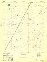
1948 Map of Desert
USGS Topo · Published 1948About this map
Fort Bliss Military Reservation dominates this 1940s landscape, illustrating the mid-century expansion of military land use in the high basin of the Tularosa Valley. The map focuses on the transit corridor through this arid terrain, anchored by the Southern Pacific railroad line which runs diagonally through the reservation. Small, isolated railway stops such as Desert and Alvarado serve as the primary points of human settlement, likely functioning as maintenance or water points for the locomotives. Geologic features like the Three Buttes rise from the valley floor, providing rare landmarks in an otherwise open expanse dotted with intermittent lakes and watering points like Alvarado Tank No 1. This planimetric study, revised from Army Air Force photography, captures the stark utility of the region just after the war.
Find a feature on this map
7 named features on this map. Tap any name to fly to it.
Don’t see what you’re looking for? This feature index may not catch every label — zoom into the map to look around manually.
Map Details
Editions of this 1948 Desert Map
This is the sole edition of this map. No revisions or reprints were ever made.
Other maps of this area

1940 · Orogrande
USGS Topo · 1:62,500

1940 · Newman
USGS Topo · 1:62,500

1941 · Desert
USGS Topo · 1:62,500

1943 · Parker Lake
USGS Topo · 1:62,500

1943 · Desert
USGS Topo · 1:62,500

1943 · Newman
USGS Topo · 1:62,500

1943 · Orogrande
USGS Topo · 1:62,500

1947 · Desert NE
USGS Topo · 1:24,000

1948 · El Wood
USGS Topo · 1:24,000
1948 · Orogrande South
USGS Topo · 1:24,000