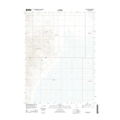
2014 Map of Desert Peak
USGS Topo · Published 2014About this map
The Newfoundland Mountains dominate this high-desert landscape in Box Elder County, rising sharply from the surrounding basins. This topographic study reveals the intricate drainage patterns of the range, including the deep cuts of Trail Canyon and Dells Canyon as they move toward the lower elevations. The summit at Desert Peak provides the central focal point for the mountain system, which is defined by a series of north-south running hollows and canyons such as Corral Hollow and Sleigh Canyon. The map illustrates the transition from steep mountain slopes to the broad, flat reaches of the Great Salt Lake Desert, providing a clear picture of the landforms and township boundaries that define this part of the Great Basin.
Find a feature on this map
10 named features on this map. Tap any name to fly to it.
Don’t see what you’re looking for? This feature index may not catch every label — zoom into the map to look around manually.
Map Details
Editions of this 2014 Desert Peak Map
This is the sole edition of this map. No revisions or reprints were ever made.
Other maps of this area

1954 · Brigham City
USGS Topo · 1:250,000

1958 · Brigham City
USGS Topo · 1:250,000

1962 · Brigham City
USGS Topo · 1:250,000

1983 · Desert Peak
USGS Topo · 1:24,000

1983 · Lemay
USGS Topo · 1:24,000

1983 · Round Mountain NW
USGS Topo · 1:24,000
1983 · Big Pass
USGS Topo · 1:24,000
1983 · Round Mountain SW
USGS Topo · 1:24,000

1983 · Groome
USGS Topo · 1:24,000
1983 · Meadow Spring
USGS Topo · 1:24,000