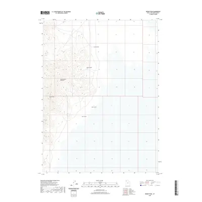
2020 Map of Desert Peak
USGS Topo · Published 2020About this map
Desert Peak stands as the central landmark of this isolated topographic profile in Box Elder County. The terrain is defined by the sharp vertical relief of the Newfoundland Mountains, a range that rises abruptly from the surrounding desert floor. This 2020 survey details the complex drainage patterns and erosion-formed features that characterize this arid landscape, including the prominent Trail Canyon and Dells Canyon. To the north, the elevation shifts into Sleigh Canyon and Corral Hollow, revealing the varied natural topography of the Great Basin. The map is a precise record of public land boundaries and physical geography in a region where natural features dictate the flow of movement across the high desert.
Find a feature on this map
6 named features on this map. Tap any name to fly to it.
Don’t see what you’re looking for? This feature index may not catch every label — zoom into the map to look around manually.
Map Details
Editions of this 2020 Desert Peak Map
This is the sole edition of this map. No revisions or reprints were ever made.
Other maps of this area

1954 · Brigham City
USGS Topo · 1:250,000

1958 · Brigham City
USGS Topo · 1:250,000

1962 · Brigham City
USGS Topo · 1:250,000

1983 · Desert Peak
USGS Topo · 1:24,000

1983 · Lemay
USGS Topo · 1:24,000

1983 · Round Mountain NW
USGS Topo · 1:24,000
1983 · Big Pass
USGS Topo · 1:24,000
1983 · Round Mountain SW
USGS Topo · 1:24,000

1983 · Groome
USGS Topo · 1:24,000
1983 · Meadow Spring
USGS Topo · 1:24,000