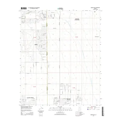
2014 Map of Desert Well
USGS Topo · Published 2014About this map
Mesa and the surrounding desert communities are captured here in a period of significant suburban expansion along the border of Maricopa and Pinal counties. The landscape is defined by a rigid grid of residential streets reaching into the arid terrain, punctuated by the major hydraulic infrastructure of the Central Arizona Project Aqueduct. To the north, the foothills near Gold Canyon and the prominent Hawk Rock provide a natural contrast to the developing neighborhoods of Springs Village and San Tan Valley. Historically significant landmarks like Desert Well sit amongst modern thoroughfares such as E Guadalupe Rd and S Signal Butte Rd. The map illustrates the complex intersection of desert hydrology and urban growth, where ephemeral drainages like Siphon Draw and Weekes Wash traverse the path of modern residential blocks in Queen Creek and Apache Junction.
Find a feature on this map
104 named features on this map. Tap any name to fly to it.
Don’t see what you’re looking for? This feature index may not catch every label — zoom into the map to look around manually.
Map Details
Editions of this 2014 Desert Well Map
This is the sole edition of this map. No revisions or reprints were ever made.
Other maps of this area

1900 · Florence
USGS Topo · 1:125,000

1902 · Florence
USGS Topo · 1:125,000

1904 · Desert Well
USGS Topo · 1:62,500

1906 · Desert Well
USGS Topo · 1:62,500

1907 · Sacaton
USGS Topo · 1:62,500

1954 · Mesa
USGS Topo · 1:250,000

1956 · Sacaton NE
USGS Topo · 1:24,000
1956 · Buckhorn
USGS Topo · 1:24,000

1956 · Goldfield
USGS Topo · 1:24,000

1956 · Magma
USGS Topo · 1:24,000