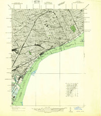
1937 Map of Detroit
USGS Topo · Published 1937About this map
Detroit River traffic and industrial intensification dominate this 1930s landscape, as the city reaches a peak of urban density. The waterfront is a complex network of R.R. Ferry routes and rail infrastructure, anchored by the Union Depot and Grand Trunk Sta. The Ambassador Bridge serves as a critical link across the international border toward Ontario, while Fort Wayne maintains its position along the river's edge.
Find a feature on this map
144 named features on this map. Tap any name to fly to it.
Don’t see what you’re looking for? This feature index may not catch every label — zoom into the map to look around manually.
Map Details
Editions of this 1937 Detroit Map
This is the sole edition of this map. No revisions or reprints were ever made.
Other maps of this area

1905 · Detroit
USGS Topo · 1:62,500

1905 · Grosse Pointe
USGS Topo · 1:62,500

1906 · Wyandotte
USGS Topo · 1:62,500

1912 · Wyandotte
USGS Topo · 1:62,500

1918 · Detroit
USGS Topo · 1:62,500

1918 · Grosse Pointe
USGS Topo · 1:62,500

1924 · Detroit
USGS Topo · 1:62,500

1929 · Wyandotte
USGS Topo · 1:62,500

1934 · Detroit
USGS Topo · 1:62,500

1936 · Wyandotte
USGS Topo · 1:31,680