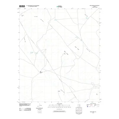
2010 Map of Devil Ridge
USGS Topo · Published 2010About this map
Old Patterson Place serves as a central point of human settlement within this arid landscape of Hudspeth County, where survival is clearly tied to water management. The terrain is dominated by the dramatic uplift of Devil Ridge and Front Ridge, which guide the drainage of intermittent watercourses like Red Hills Arroyo and Red Light Draw. These features reflect the complex geomorphology of the Trans-Pecos region, where cattle ranching infrastructure is the primary visible industry. Numerous man-made water catchments, such as Rock Tank, Coffee Tank, and New Dagger Tank, are distributed across the flats and mesas. Transportation in this era relied on arterial routes like Indian Hot Springs Rd, connecting isolated landmarks such as East Windmill and Cummins Windmill through the desert floor near Yucca Mesa.
Find a feature on this map
20 named features on this map. Tap any name to fly to it.
Don’t see what you’re looking for? This feature index may not catch every label — zoom into the map to look around manually.
Map Details
Editions of this 2010 Devil Ridge Map
This is the sole edition of this map. No revisions or reprints were ever made.
Other maps of this area

1895 · Sierra Blanca
USGS Topo · 1:125,000

1897 · Eagle Mountain
USGS Topo · 1:125,000

1916 · Eagle Mountain
USGS Topo · 1:125,000

1954 · Van Horn
USGS Topo · 1:250,000

1958 · Van Horn
USGS Topo · 1:250,000

1959 · Marfa
USGS Topo · 1:250,000
1963 · Grayton Lake
USGS Topo · 1:24,000

1964 · Devil Ridge
USGS Topo · 1:24,000

1964 · Dome Peak
USGS Topo · 1:24,000

1964 · Lasca
USGS Topo · 1:24,000