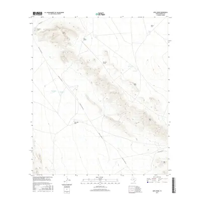
2016 Map of Devil Ridge
USGS Topo · Published 2016About this map
Devil Ridge forms a prominent topographic spine through this arid corner of Hudspeth County, serving as a primary landmark for navigation in a landscape defined by seasonal water catchments and ranching infrastructure. The network of stock tanks, including Old Dagger Tank, Fivemile Tank, and Rock Tank, illustrates the essential water management required for life in the Trans-Pecos region. Higher elevations are marked by Yucca Mesa and Front Ridge, while the lowlands are dissected by drainage systems like Red Light Draw and Blanca Draw. Remote access is facilitated by the long stretch of Indian Hot Springs Rd and Ranch Rd 1111, which connect isolated ranching points to the larger Texas highway system. This terrain represents the classic high-desert environment of West Texas, where geographical features like Fivemile Point and the Red Hills provide the few permanent reference points in an open, expansive landscape.
Find a feature on this map
19 named features on this map. Tap any name to fly to it.
Don’t see what you’re looking for? This feature index may not catch every label — zoom into the map to look around manually.
Map Details
Editions of this 2016 Devil Ridge Map
This is the sole edition of this map. No revisions or reprints were ever made.
Other maps of this area

1895 · Sierra Blanca
USGS Topo · 1:125,000

1897 · Eagle Mountain
USGS Topo · 1:125,000

1916 · Eagle Mountain
USGS Topo · 1:125,000

1954 · Van Horn
USGS Topo · 1:250,000

1958 · Van Horn
USGS Topo · 1:250,000

1959 · Marfa
USGS Topo · 1:250,000
1963 · Grayton Lake
USGS Topo · 1:24,000

1964 · Devil Ridge
USGS Topo · 1:24,000

1964 · Dome Peak
USGS Topo · 1:24,000

1964 · Lasca
USGS Topo · 1:24,000