
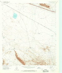
1964 Map of Devil Ridge
USGS Topo · Published 1967About this map
Devil Ridge and Front Ridge dominate this arid landscape in Hudspeth County, where the topography transitions from the high, flat expanse of Yucca Mesa down through Echo Canyon into the expansive Red Light Draw. In the mid-1960s, this region remained a remote environment defined by isolated ranching infrastructure and historic pathways. The route of the Old Spanish Trail cuts across the basin, providing a clear view of the historical transportation corridors that navigated this desert terrain. Scattered water sources, critical for survival and livestock, include Old Dagger Tank, Cummins Windmill, and Hayter Well. Evidence of human presence is sparse but specific, marked by the Old Patterson Place and a small Gravel Pit near the northern boundary, illustrating the modest scale of settlement and industry in this corner of West Texas.
Find a feature on this map
22 named features on this map. Tap any name to fly to it.
Don’t see what you’re looking for? This feature index may not catch every label — zoom into the map to look around manually.
Map Details
Editions of this 1964 Devil Ridge Map
This is the sole edition of this map. No revisions or reprints were ever made.
Other maps of this area

1895 · Sierra Blanca
USGS Topo · 1:125,000

1897 · Eagle Mountain
USGS Topo · 1:125,000

1916 · Eagle Mountain
USGS Topo · 1:125,000

1954 · Van Horn
USGS Topo · 1:250,000

1958 · Van Horn
USGS Topo · 1:250,000

1959 · Marfa
USGS Topo · 1:250,000
1963 · Grayton Lake
USGS Topo · 1:24,000

1964 · Dome Peak
USGS Topo · 1:24,000

1964 · Lasca
USGS Topo · 1:24,000

1964 · Sierra Blanca SW
USGS Topo · 1:24,000