
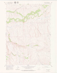
1960 Map of Devil Slide
USGS Topo · Published 1962About this map
The Devil Slide landmark anchors this 1960s survey of the Wyoming high desert, where deep drainage systems like Grass Creek and Jones Creek have carved significant breaks into the topography. The map illustrates a landscape of high-altitude ranching and livestock infrastructure, marked by the lone Nickelson Place and named grazing areas such as the Jack Welch Basin.
Find a feature on this map
19 named features on this map. Tap any name to fly to it.
Don’t see what you’re looking for? This feature index may not catch every label — zoom into the map to look around manually.
Map Details
Editions of this 1960 Devil Slide Map
2 editions found
Other maps of this area

1951 · Boysen
USGS Topo · 1:24,000

1951 · Birdseye Pass
USGS Topo · 1:24,000

1952 · Guffy Peak
USGS Topo · 1:24,000

1955 · Thermopolis
USGS Topo · 1:250,000

1955 · Arminto
USGS Topo · 1:250,000

1958 · Thermopolis
USGS Topo · 1:250,000

1958 · Arminto
USGS Topo · 1:250,000

1960 · Coyote Hill
USGS Topo · 1:24,000
1960 · Blue Hill
USGS Topo · 1:24,000

1960 · Red Hole
USGS Topo · 1:24,000