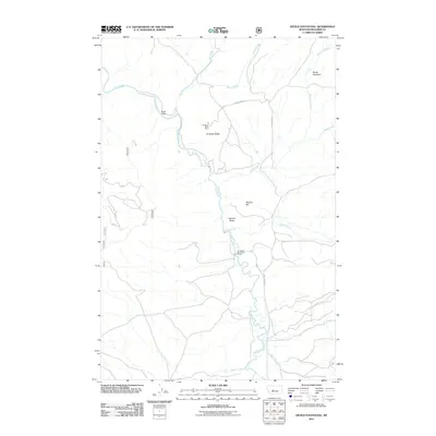
2011 Map of Devils Footstool
USGS Topo · Published 2011About this map
The Smith River carves a winding path through this corner of Meagher County, serving as the central geographic feature of the region. This landscape is defined by its dramatic topographic rises, most notably the towering Devils Footstool in the northeast and the prominent Songster Butte near the river's bend. Evidence of historical land use and resource extraction is found at the Songster Butte Mine, while the Fort Baker Sportsmans Access indicates the area's continued importance for recreation and river navigation. Numerous tributaries, including Shannon Creek and Sheep Creek, feed into the main waterway, dissecting the terrain around local landmarks like Berkins Butte and Buck Gulch. Local transit is facilitated by primitive routes such as Chris Ahern Rd and Smith River Rd, which trace the high ground and riverbanks.
Find a feature on this map
22 named features on this map. Tap any name to fly to it.
Don’t see what you’re looking for? This feature index may not catch every label — zoom into the map to look around manually.
Map Details
Editions of this 2011 Devils Footstool Map
This is the sole edition of this map. No revisions or reprints were ever made.
Other maps of this area

1886 · Fort Logan
USGS Topo · 1:250,000

1948 · White Sulphur Springs
USGS Topo · 1:250,000

1958 · White Sulphur Springs
USGS Topo · 1:250,000

1961 · White Sulphur Springs
USGS Topo · 1:250,000

1965 · White Sulphur Springs
USGS Topo · 1:250,000

1966 · Watson
USGS Topo · 1:24,000

1966 · Lingshire NE
USGS Topo · 1:24,000
1966 · Ellis Canyon
USGS Topo · 1:24,000
1971 · Bald Hills
USGS Topo · 1:24,000
1971 · Monument Peak
USGS Topo · 1:24,000