
1966 Map of Watson
USGS Topo · Published 1970About this map
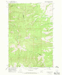
The Helena National Forest dominates this mid-1960s landscape, where the rugged topography of the Big Belt Mountains is etched by dozens of steep gulches and high-altitude camps. Historical resource extraction is evident near the center of the sheet, where a Dredge and Tailings Creek suggest significant earth-moving activity along the water. These industrial marks contrast with the isolated outpost of Watson, located near the intersection of Benton Gulch and Vermont Gulch.
Find a feature on this map
36 named features on this map. Tap any name to fly to it.
Don’t see what you’re looking for? This feature index may not catch every label — zoom into the map to look around manually.
Map Details
Editions of this 1966 Watson Map
This is the sole edition of this map. No revisions or reprints were ever made.
Other maps of this area

1886 · Fort Logan
USGS Topo · 1:250,000

1948 · White Sulphur Springs
USGS Topo · 1:250,000

1958 · White Sulphur Springs
USGS Topo · 1:250,000

1961 · White Sulphur Springs
USGS Topo · 1:250,000

1965 · White Sulphur Springs
USGS Topo · 1:250,000
1966 · Boulder Baldy
USGS Topo · 1:24,000
1966 · Diamond City
USGS Topo · 1:24,000
1966 · Lingshire
USGS Topo · 1:24,000
1966 · Whites City
USGS Topo · 1:24,000

1966 · Ellis Canyon
USGS Topo · 1:24,000