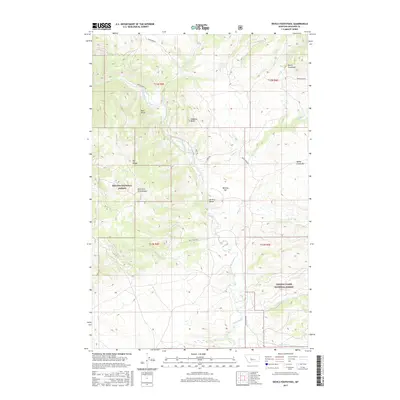
2017 Map of Devils Footstool
USGS Topo · Published 2017About this map
The Smith River winds through this section of Meagher County, carving a path between the Helena National Forest to the west and the Lewis & Clark National Forest to the southeast. This 2017 study illustrates a rugged Montana landscape defined by prominent landforms like Devils Footstool and Berkins Butte. The river's influence on the local geography is evident in the presence of named gravel bars such as Berkins Bar and Sheep Creek Bar, which are significant markers for both river navigation and geological study.
Find a feature on this map
27 named features on this map. Tap any name to fly to it.
Don’t see what you’re looking for? This feature index may not catch every label — zoom into the map to look around manually.
Map Details
Editions of this 2017 Devils Footstool Map
This is the sole edition of this map. No revisions or reprints were ever made.
Other maps of this area

1886 · Fort Logan
USGS Topo · 1:250,000

1948 · White Sulphur Springs
USGS Topo · 1:250,000

1958 · White Sulphur Springs
USGS Topo · 1:250,000

1961 · White Sulphur Springs
USGS Topo · 1:250,000

1965 · White Sulphur Springs
USGS Topo · 1:250,000

1966 · Watson
USGS Topo · 1:24,000

1966 · Lingshire NE
USGS Topo · 1:24,000
1966 · Ellis Canyon
USGS Topo · 1:24,000
1971 · Bald Hills
USGS Topo · 1:24,000
1971 · Monument Peak
USGS Topo · 1:24,000