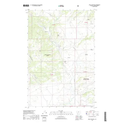
2020 Map of Devils Footstool
USGS Topo · Published 2020About this map
The Smith River winds through this central Montana landscape, carving a path between the northern reaches of the Helena National Forest and the Lewis & Clark National Forest. The terrain is defined by the high elevations of the Little Belt Mountains and the Dry Range, with the distinctive landmark of Devils Footstool rising in the northeast. This area represents a rugged corridor of public land where early ranching and transit infrastructure followed the natural breaks in the topography. Numerous alluvial features such as Berkins Bar and Sheep Creek Bar line the river, while established routes like Smith River Rd and Spring Creek Trl provide access to the remote interior. Prominent heights including Songster Butte and Berkins Butte overlook a network of drainages such as Sheep Cr and Beaver Cr, marking a landscape of significant importance to the regional watershed.
Find a feature on this map
31 named features on this map. Tap any name to fly to it.
Don’t see what you’re looking for? This feature index may not catch every label — zoom into the map to look around manually.
Map Details
Editions of this 2020 Devils Footstool Map
This is the sole edition of this map. No revisions or reprints were ever made.
Other maps of this area

1886 · Fort Logan
USGS Topo · 1:250,000

1948 · White Sulphur Springs
USGS Topo · 1:250,000

1958 · White Sulphur Springs
USGS Topo · 1:250,000

1961 · White Sulphur Springs
USGS Topo · 1:250,000

1965 · White Sulphur Springs
USGS Topo · 1:250,000

1966 · Watson
USGS Topo · 1:24,000

1966 · Lingshire NE
USGS Topo · 1:24,000
1966 · Ellis Canyon
USGS Topo · 1:24,000
1971 · Bald Hills
USGS Topo · 1:24,000
1971 · Monument Peak
USGS Topo · 1:24,000