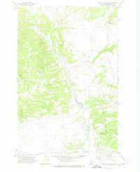
1971 Map of Devils Footstool
USGS Topo · Published 1975About this map
The Smith River carves a winding path through this corner of Meagher County, serving as the central drainage for a landscape defined by prominent landforms and high-elevation watersheds. This 1970s survey documents a wilderness boundary where the Helena National Forest and the Lewis and Clark National Forest meet. Distinctive landmarks such as the Devils Footstool and Songster Butte rise above the river valley, while the Dry Range dominates the western topography.
Find a feature on this map
24 named features on this map. Tap any name to fly to it.
Don’t see what you’re looking for? This feature index may not catch every label — zoom into the map to look around manually.
Map Details
Editions of this 1971 Devils Footstool Map
This is the sole edition of this map. No revisions or reprints were ever made.
Other maps of this area

1886 · Fort Logan
USGS Topo · 1:250,000

1948 · White Sulphur Springs
USGS Topo · 1:250,000

1958 · White Sulphur Springs
USGS Topo · 1:250,000

1961 · White Sulphur Springs
USGS Topo · 1:250,000

1965 · White Sulphur Springs
USGS Topo · 1:250,000

1966 · Watson
USGS Topo · 1:24,000

1966 · Lingshire NE
USGS Topo · 1:24,000
1966 · Ellis Canyon
USGS Topo · 1:24,000
1971 · Bald Hills
USGS Topo · 1:24,000
1971 · Monument Peak
USGS Topo · 1:24,000