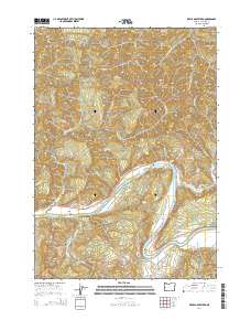
2014 Map of Devils Graveyard
USGS Topo · Published 2014About this map
Umpqua River frontage and the surrounding timberlands of Douglas County define this landscape, where the water cuts through high ridges like Scare Ridge. The river's path is marked by hazards and landmarks such as Sawyer Rapids and Bunch Bar, reflecting the area's history as a navigable but challenging corridor. Settlement is sparse, focused around the Long Prairie area and accessible via a network of rural roads such as Wells Creek Rd and Paradise Creek Rd. Family and local history can be traced to the Brown Cem and the evocatively named Devils Graveyard terrain feature. The map details numerous drainages, including Weatherly Creek and Paradise Cr, which feed the main river system amidst steep elevations and Bureau of Land Management tracts.
Find a feature on this map
40 named features on this map. Tap any name to fly to it.
Don’t see what you’re looking for? This feature index may not catch every label — zoom into the map to look around manually.
Map Details
Editions of this 2014 Devils Graveyard Map
This is the sole edition of this map. No revisions or reprints were ever made.
Other maps of this area

1919 · Earl
USGS Topo · 1:48,000

1942 · Roman Nose Mtn
USGS Topo · 1:62,500

1943 · Goodwin Peak
USGS Topo · 1:62,500

1945 · Roman Nose Mtn
USGS Topo · 1:62,500

1955 · Scottsburg
USGS Topo · 1:62,500

1955 · Elkton
USGS Topo · 1:62,500
1956 · Goodwin Peak
USGS Topo · 1:62,500

1958 · Roseburg
USGS Topo · 1:250,000

1959 · Roseburg
USGS Topo · 1:250,000

1979 · Cottage Grove
USGS Topo · 1:100,000