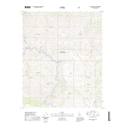
2021 Map of Devils Heart Peak
USGS Topo · Published 2021About this map
Devils Heart Peak and the high ridges of the Topatopa Mountains anchor this modern topographic view of the California backcountry. Located within the Los Padres National Forest, the landscape is defined by the protected corridor of the Sespe Creek Wild and Scenic River. The map captures a topography of steep canyons and isolated high-elevation meadows, locally known as flats. These include Cottriel Flat, Pigeon Flat, and Squaw Flat, which often served as key landmarks for travelers through these mountains. Remote water sources are meticulously documented, from Sespe Hot Springs in the northwest to the many seasonal flows like Stone Corral Cr and Agua Blanca Cr. Footpaths and primitive routes such as the Sespe River Trl and Bucksnort Trl provide the only access into these roadless areas, save for the single track of Squaw Flat Rd reaching into the southern interior.
Find a feature on this map
43 named features on this map. Tap any name to fly to it.
Don’t see what you’re looking for? This feature index may not catch every label — zoom into the map to look around manually.
Map Details
Editions of this 2021 Devils Heart Peak Map
This is the sole edition of this map. No revisions or reprints were ever made.
Other maps of this area

1900 · Piru
USGS Topo · 1:62,500

1903 · Santa Paula
USGS Topo · 1:62,500

1903 · Mt. Pinos
USGS Topo · 1:125,000

1903 · Tejon
USGS Topo · 1:125,000

1903 · Camulos
USGS Topo · 1:125,000

1921 · Piru
USGS Topo · 1:62,500

1938 · Black Mountain
USGS Topo · 1:24,000

1941 · Piru
USGS Topo · 1:62,500

1942 · Santa Paula
USGS Topo · 1:62,500

1943 · Topatopa Mountains
USGS Topo · 1:24,000