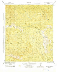
1944 Map of Devils Heart Peak
USGS Topo · Published 1944About this map
Sespe Game Refuge dominates this mid-century topographic study, revealing a landscape defined by deep canyons and isolated outposts in the Los Padres National Forest. The Mc Donald Cabin stands as a solitary named human landmark in the northern section, while the drainage of Sespe Creek and its many tributaries, including Alder Creek and Agua Blanca Creek, carve the complex terrain.
Find a feature on this map
30 named features on this map. Tap any name to fly to it.
Don’t see what you’re looking for? This feature index may not catch every label — zoom into the map to look around manually.
Map Details
Editions of this 1944 Devils Heart Peak Map
This is the sole edition of this map. No revisions or reprints were ever made.
Other maps of this area

1900 · Piru
USGS Topo · 1:62,500

1903 · Santa Paula
USGS Topo · 1:62,500

1903 · Mt. Pinos
USGS Topo · 1:125,000

1903 · Tejon
USGS Topo · 1:125,000

1903 · Camulos
USGS Topo · 1:125,000

1921 · Piru
USGS Topo · 1:62,500

1938 · Black Mountain
USGS Topo · 1:24,000

1941 · Piru
USGS Topo · 1:62,500

1942 · Santa Paula
USGS Topo · 1:62,500

1943 · Topatopa Mountains
USGS Topo · 1:24,000