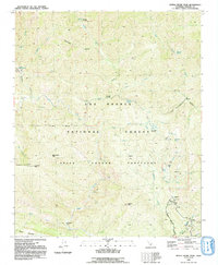
1991 Map of Devils Heart Peak
USGS Topo · Published 1991About this map
Sespe Condor Sanctuary dominates this portion of the Los Padres National Forest in the early 1990s, centering on the prominent Devils Heart Peak. The landscape is defined by the deep drainage of Sespe Creek and its many tributaries, including Alder Creek and Agua Blanca Creek. Evidence of backcountry travel and land management appears in the form of remote locations like McDonald Campsite and Cow Spring Campsite, while the steep terrain is marked by numerous falls and named summits such as Topatopa Peak and Sulphur Peak.
Find a feature on this map
48 named features on this map. Tap any name to fly to it.
Don’t see what you’re looking for? This feature index may not catch every label — zoom into the map to look around manually.
Map Details
Editions of this 1991 Devils Heart Peak Map
2 editions found
Other maps of this area

1900 · Piru
USGS Topo · 1:62,500

1903 · Santa Paula
USGS Topo · 1:62,500

1903 · Mt. Pinos
USGS Topo · 1:125,000

1903 · Tejon
USGS Topo · 1:125,000

1903 · Camulos
USGS Topo · 1:125,000

1921 · Piru
USGS Topo · 1:62,500

1938 · Black Mountain
USGS Topo · 1:24,000

1941 · Piru
USGS Topo · 1:62,500

1942 · Santa Paula
USGS Topo · 1:62,500

1943 · Topatopa Mountains
USGS Topo · 1:24,000