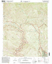
1995 Map of Devils Heart Peak
USGS Topo · Published 2000About this map
The Sespe Condor Sanctuary dominates this portion of the Los Padres National Forest, a terrain of steep canyons and high peaks in Ventura County. The protected status of this landscape is evidenced by the inclusion of the Sespe Wilderness and the winding course of the Sespe Wild and Scenic River. Geologic and geothermal activity is noted by the presence of Sespe Hot Springs and Oil Wells located near the eastern boundary. Several established backcountry locations such as Dough Flat, Cottriel Flat Campsite, and McDonald Cabin Campsite provide points of reference for those navigating the trail systems. Elevations reach their height at Topatopa Peak and the namesake Devils Heart Peak, overlooking a complex network of drainages including Alder Creek and Sycamore Canyon.
Find a feature on this map
50 named features on this map. Tap any name to fly to it.
Don’t see what you’re looking for? This feature index may not catch every label — zoom into the map to look around manually.
Map Details
Editions of this 1995 Devils Heart Peak Map
This is the sole edition of this map. No revisions or reprints were ever made.
Other maps of this area

1900 · Piru
USGS Topo · 1:62,500

1903 · Santa Paula
USGS Topo · 1:62,500

1903 · Mt. Pinos
USGS Topo · 1:125,000

1903 · Tejon
USGS Topo · 1:125,000

1903 · Camulos
USGS Topo · 1:125,000

1921 · Piru
USGS Topo · 1:62,500

1938 · Black Mountain
USGS Topo · 1:24,000

1941 · Piru
USGS Topo · 1:62,500

1942 · Santa Paula
USGS Topo · 1:62,500

1943 · Topatopa Mountains
USGS Topo · 1:24,000