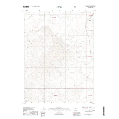
2021 Map of Devils Playground
USGS Topo · Published 2021About this map
Devils Playground characterizes the high-desert terrain of Sweetwater County in this 2021 topographic record. The landscape is defined by significant elevations such as Black Mtn and the prominent Twin Buttes in the southwest corner, showing a land of dramatic relief and deep drainages. A portion of the Ashley National Forest occupies the northeastern corner of the map, where the terrain begins to transition toward the forest boundary. Human presence is sparse, marked primarily by Mckinnon Rd cutting across the northwest and isolated water sources like Pine Spring. The presence of named landmarks like Squaw Hollow and various reservoirs suggests a landscape managed for grazing and resource use within the grid of township and range lines.
Find a feature on this map
13 named features on this map. Tap any name to fly to it.
Don’t see what you’re looking for? This feature index may not catch every label — zoom into the map to look around manually.
Map Details
Editions of this 2021 Devils Playground Map
This is the sole edition of this map. No revisions or reprints were ever made.
Other maps of this area

1954 · Rock Springs
USGS Topo · 1:250,000

1957 · Mc Kinnon Junction
USGS Topo · 1:62,500

1958 · Rock Springs
USGS Topo · 1:250,000

1962 · Rock Springs
USGS Topo · 1:250,000

1964 · Black Spring Reservoir
USGS Topo · 1:24,000
1964 · Antelope Wash
USGS Topo · 1:24,000

1964 · Winter Fat Reservoir
USGS Topo · 1:24,000

1966 · Mc Kinnon Junction
USGS Topo · 1:62,500

1966 · Buckboard Crossing
USGS Topo · 1:62,500
1980 · Firehole Canyon
USGS Topo · 1:100,000