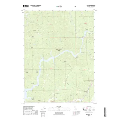
2018 Map of Devils Rock
USGS Topo · Published 2018About this map
The Shasta National Forest dominates this landscape in Shasta County, where the topography is defined by the complex branching of the Pit River. This terrain is marked by significant elevation changes, from the heights of Chirpchatter Mtn and Brock Mtn down to the deeply recessed waters of the Pit River Arm. The map reveals a wild geography of named gulches and ridges, such as Croxford Ridge and Constant Flow Gulch, which dictate the drainage patterns of Stein Creek and Potem Cr. While the northern reaches are dominated by steep canyons like Madison Canyon, the southern section transitions toward more accessible terrain near Arbuckle Flat. This late 2010s survey shows a sparsely populated region primarily accessed via forest routes and small mountain roads like Mineral School Rd, highlighting the enduring isolation of this part of the California wilderness.
Find a feature on this map
51 named features on this map. Tap any name to fly to it.
Don’t see what you’re looking for? This feature index may not catch every label — zoom into the map to look around manually.
Map Details
Editions of this 2018 Devils Rock Map
This is the sole edition of this map. No revisions or reprints were ever made.
Other maps of this area

1886 · Lassen Peak
USGS Topo · 1:250,000

1890 · Red Bluff
USGS Topo · 1:250,000

1892 · Lassen Peak
USGS Topo · 1:250,000

1894 · Lassen Peak
USGS Topo · 1:250,000

1894 · Red Bluff
USGS Topo · 1:250,000

1901 · Redding
USGS Topo · 1:125,000

1935 · Burney
USGS Topo · 1:96,000

1939 · Burney
USGS Topo · 1:125,000

1949 · Bollibokka Mtn
USGS Topo · 1:62,500

1953 · Millville
USGS Topo · 1:62,500