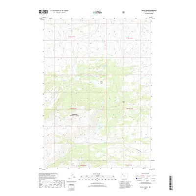
2017 Map of Devils Tooth
USGS Topo · Published 2017About this map
Shoshone National Forest dominates the high-altitude landscape of this Park County region, where the terrain is defined by the sharp verticality of Devils Tooth. The drainage patterns show a complex network of alpine waterways, including Marquette Cr, Sulphur Cr, and Meeteetse Cr, which carve through the elevations. Water management is a visible priority in this arid environment, evidenced by several high-mountain impoundments such as Darrah Number 2 Reservoir, Coe Reservoir, and Foster Reservoir. The presence of Pete Miller Park and Hidden Lake suggests a landscape utilized for both resource management and recreation. Infrastructure is sparse, concentrated primarily along the southern edge with Meeteetse Creek Rd, reflecting the remote and protected nature of the forest lands in the early 21st century.
Find a feature on this map
26 named features on this map. Tap any name to fly to it.
Don’t see what you’re looking for? This feature index may not catch every label — zoom into the map to look around manually.
Map Details
Editions of this 2017 Devils Tooth Map
This is the sole edition of this map. No revisions or reprints were ever made.
Other maps of this area

1955 · Cody
USGS Topo · 1:250,000

1957 · Wapiti
USGS Topo · 1:62,500

1957 · Devils Tooth
USGS Topo · 1:62,500

1957 · Irish Rock
USGS Topo · 1:62,500

1957 · Sunshine Reservoir
USGS Topo · 1:62,500

1958 · Cody
USGS Topo · 1:250,000

1962 · Cody
USGS Topo · 1:250,000

1980 · Carter Mountain
USGS Topo · 1:100,000
1987 · Devils Tooth
USGS Topo · 1:24,000
1987 · Irma Flats
USGS Topo · 1:24,000