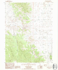
1986 Map of Devon Peak
USGS Topo · Published 1987About this map
Mountain Boy Range and the Mahogany Hills dominate this high-desert landscape in central Nevada, where the legacy of silver and lead mining is etched into the terrain. Extensive mining operations are concentrated in the southern reaches, featuring the Silver Lick Mine, Wales Mine, and the Price & Davis Mine, alongside numerous mineshafts and mine tunnels. These industrial sites sit at the edge of the Diamond Valley, a broad basin floor supporting the Eureka Airport and a modern Trailer Park.
Find a feature on this map
32 named features on this map. Tap any name to fly to it.
Don’t see what you’re looking for? This feature index may not catch every label — zoom into the map to look around manually.
Map Details
Editions of this 1986 Devon Peak Map
This is the sole edition of this map. No revisions or reprints were ever made.
Other maps of this area

1926 · Roberts Mountains
USGS Topo · 1:250,000

1929 · Roberts Mountains
USGS Topo · 1:250,000

1953 · Pinto Summit
USGS Topo · 1:62,500

1953 · Eureka
USGS Topo · 1:62,500

1955 · Millett
USGS Topo · 1:250,000

1956 · Bellevue Peak
USGS Topo · 1:62,500

1956 · Whistler Mtn
USGS Topo · 1:62,500

1956 · Ely
USGS Topo · 1:250,000

1959 · Ely
USGS Topo · 1:250,000

1959 · Millett
USGS Topo · 1:250,000