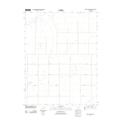
2012 Map of Dewey Ranch SE
USGS Topo · Published 2012About this map
Beaver Cr meanders through the northwestern corner of this Kansas landscape, defining a rural territory primarily organized by a rigid grid of section-line roads. This portion of Rawlins County is characterized by its drainage into the Sappa Creek system, with the N Fork Sappa Cr and Middle Fork Sappa Cr cutting across the high plains. The map reflects a modern agricultural environment where transportation is dictated by the county road system, including through-routes like Co Road DD and Co Road CC. Small intermittent water bodies and ponds are scattered across the quadrants, suggesting the importance of water management in this dryland farming and ranching region. The absence of concentrated town centers emphasizes the area's identity as an open ranching landscape defined by topography and surveyor lines rather than urban development.
Find a feature on this map
14 named features on this map. Tap any name to fly to it.
Don’t see what you’re looking for? This feature index may not catch every label — zoom into the map to look around manually.
Map Details
Editions of this 2012 Dewey Ranch SE Map
This is the sole edition of this map. No revisions or reprints were ever made.
Other maps of this area

1943 · Colby
USGS Topo · 1:62,500

1951 · Chardon
USGS Topo · 1:62,500

1951 · Dewey Ranch
USGS Topo · 1:62,500

1954 · Goodland
USGS Topo · 1:250,000

1956 · Goodland
USGS Topo · 1:250,000

1957 · Goodland
USGS Topo · 1:250,000

1966 · Brewster NW
USGS Topo · 1:24,000

1967 · Brewster NE
USGS Topo · 1:24,000

1967 · Levant
USGS Topo · 1:24,000
1981 · Dewey Ranch SW
USGS Topo · 1:24,000