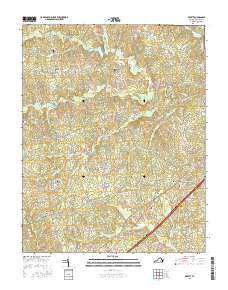
2016 Map of DeWitt
USGS Topo · Published 2016About this map
DeWitt and Butterworth serve as the primary focal points of this Dinwiddie County landscape, situated along the diagonal path of the Boydton Plank Rd. This 2016 survey illustrates a rural region defined by its dispersed family-named cemeteries and a complex network of creeks. Numerous burial sites, including Meredith Cem, Hill Cem, and Eleven Oaks Cem, are scattered across the terrain, offering significant touchpoints for genealogical research and local heritage.
Find a feature on this map
55 named features on this map. Tap any name to fly to it.
Don’t see what you’re looking for? This feature index may not catch every label — zoom into the map to look around manually.
Map Details
Editions of this 2016 DeWitt Map
This is the sole edition of this map. No revisions or reprints were ever made.
Other maps of this area

1897 · Amelia
USGS Topo · 1:125,000

1918 · Lawrenceville
USGS Topo · 1:62,500

1919 · Mc Kenney
USGS Topo · 1:48,000

1920 · Lawrenceville
USGS Topo · 1:48,000

1921 · Mc Kenney
USGS Topo · 1:62,500

1921 · Lawrenceville
USGS Topo · 1:62,500

1942 · Lawrenceville
USGS Topo · 1:62,500

1943 · Mc Kenney
USGS Topo · 1:62,500

1943 · De Witt
USGS Topo · 1:24,000

1943 · Dinwiddie
USGS Topo · 1:24,000