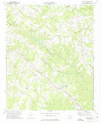
1973 Map of Dewy Rose
USGS Topo · Published 1975About this map
The Southern railroad corridor dictates the settlement pattern of this rural Elbert and Hart County landscape in the early 1970s, threading through small communities like Dewy Rose, Hard Cash, and Goss. The terrain is deeply etched by the drainage networks of Beaverdam Creek and Coldwater Creek, creating a tapestry of wooded ridges and small agricultural clearings. Local identity is anchored by a dense network of country churches, including Liberty Ch, Maple Spring Ch, and Norman Grove Ch.
Find a feature on this map
36 named features on this map. Tap any name to fly to it.
Don’t see what you’re looking for? This feature index may not catch every label — zoom into the map to look around manually.
Map Details
Editions of this 1973 Dewy Rose Map
This is the sole edition of this map. No revisions or reprints were ever made.
Other maps of this area

1891 · Carnesville
USGS Topo · 1:125,000

1893 · Elberton
USGS Topo · 1:125,000

1954 · Greenville
USGS Topo · 1:250,000

1958 · Greenville
USGS Topo · 1:250,000

1958 · Danielsville
USGS Topo · 1:62,500

1958 · Elberton
USGS Topo · 1:62,500

1959 · Hartwell Dam
USGS Topo · 1:24,000

1959 · Royston
USGS Topo · 1:24,000

1959 · Hartwell
USGS Topo · 1:24,000
1972 · Bowman
USGS Topo · 1:24,000