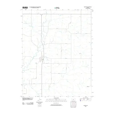
2010 Map of Dexter
USGS Topo · Published 2010About this map
Dexter serves as the central hub of this Cowley County landscape, situated where Grouse Creek and Plum Creek converge. The town's street grid is clearly defined, transitioning into a vast network of numbered section roads that partition the agricultural land. In the southeastern corner lies Hooser, a small community located along a section of 291st Rd. The drainage patterns are a defining characteristic of the area, with Turkey Creek flowing from the northwest to join the larger Grouse Creek drainage system, while Crabb Creek and its tributary Little Crabb Creek wind through the southern sections. This map documents a quiet rural period where the orientation of farms and travel remains dictated by the intricate creek systems and the rigid township and range road network.
Find a feature on this map
26 named features on this map. Tap any name to fly to it.
Don’t see what you’re looking for? This feature index may not catch every label — zoom into the map to look around manually.
Map Details
Editions of this 2010 Dexter Map
This is the sole edition of this map. No revisions or reprints were ever made.
Other maps of this area

1889 · Burden
USGS Topo · 1:125,000

1955 · Wichita
USGS Topo · 1:250,000

1958 · Wichita
USGS Topo · 1:250,000
1962 · Cedar Vale West
USGS Topo · 1:24,000

1962 · Dexter SW
USGS Topo · 1:24,000

1962 · Grand Summit
USGS Topo · 1:24,000

1962 · Dexter
USGS Topo · 1:24,000
1962 · Dexter NE
USGS Topo · 1:24,000

1962 · Cambridge
USGS Topo · 1:24,000

1964 · Burden
USGS Topo · 1:24,000