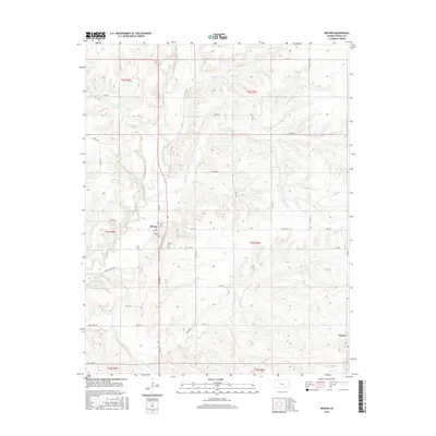
2015 Map of Dexter
USGS Topo · Published 2015About this map
Dexter serves as the primary hub of this Cowley County landscape, where the street grid of Kansas Ave and N Maple St meets the winding path of Grouse Creek. The terrain is defined by a dense network of drainage systems, with Bullington Cr in the north and the converging branches of Crabb Cr and Little Crabb Cr to the south. This 2015 U.S. Geological Survey representation documents the modern rural infrastructure, from the Dexter Cem on the western edge of town to the small settlement of Hooser in the southeast corner. The section lines of the Public Land Survey System, such as t33s r7e, dictate a regular grid of gravel and paved roads like 243rd Rd and Grouse Creek Rd, which navigate around the deeply etched creek valleys and prairie ridges typical of this region.
Find a feature on this map
43 named features on this map. Tap any name to fly to it.
Don’t see what you’re looking for? This feature index may not catch every label — zoom into the map to look around manually.
Map Details
Editions of this 2015 Dexter Map
This is the sole edition of this map. No revisions or reprints were ever made.
Other maps of this area

1889 · Burden
USGS Topo · 1:125,000

1955 · Wichita
USGS Topo · 1:250,000

1958 · Wichita
USGS Topo · 1:250,000
1962 · Cedar Vale West
USGS Topo · 1:24,000

1962 · Dexter SW
USGS Topo · 1:24,000

1962 · Grand Summit
USGS Topo · 1:24,000

1962 · Dexter
USGS Topo · 1:24,000
1962 · Dexter NE
USGS Topo · 1:24,000

1962 · Cambridge
USGS Topo · 1:24,000

1964 · Burden
USGS Topo · 1:24,000