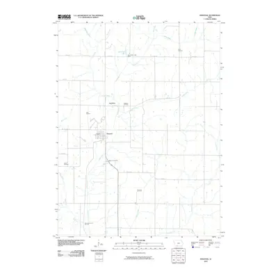
2010 Map of Diagonal
USGS Topo · Published 2010About this map
Diagonal and the neighboring settlement of Knowlton anchor this Ringgold County landscape, situated where the Grand River and several tributary creeks like Wolf Creek and Plum Creek carve through the Iowa countryside. The town of Diagonal is characterized by its organized grid and the Diagonal Post Office, serving as a local hub for the surrounding agricultural community. To the north, the Sun Valley Lake Dam contains the waters of Sun Valley Lake, a significant local water feature that contrasts with the traditional farm-to-market road network including Co RD j23.
Find a feature on this map
27 named features on this map. Tap any name to fly to it.
Don’t see what you’re looking for? This feature index may not catch every label — zoom into the map to look around manually.
Map Details
Editions of this 2010 Diagonal Map
This is the sole edition of this map. No revisions or reprints were ever made.
Other maps of this area

1940 · Blockton
USGS Topo · 1:62,500

1943 · Blockton
USGS Topo · 1:62,500

1945 · Mount Ayr
USGS Topo · 1:62,500

1947 · Mount Ayr
USGS Topo · 1:62,500

1955 · Nebraska City
USGS Topo · 1:250,000

1957 · Nebraska City
USGS Topo · 1:250,000

1958 · Nebraska City
USGS Topo · 1:250,000
1981 · Arispe
USGS Topo · 1:24,000
1981 · Shannon City
USGS Topo · 1:24,000
1981 · Diagonal
USGS Topo · 1:24,000