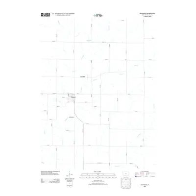
2013 Map of Diagonal
USGS Topo · Published 2013About this map
Diagonal stands as the primary hub of this Ringgold County landscape, where a grid of residential streets like W 7th St and W 4th St meets the agricultural expanse of southern Iowa. The Grand River meanders through the central terrain, joined by numerous tributaries including Plum Cr and Squaw Cr, illustrating the well-watered nature of these prairie lands. To the north, the development at Sun Valley Lake represents a shift toward modern recreation, contrasted by the quiet vicinity of Knowlton. The southern reaches are defined by the Kokesh County Recreation Area, providing a dedicated space for public use near the riverbanks. A dense network of section-line roads, such as Co Hwy-P33 and 190th St, provides the framework for the region's farming heritage, connecting the scattered settlements and natural landmarks across the drainage basins of Crooked Cr and Wolf Cr.
Find a feature on this map
46 named features on this map. Tap any name to fly to it.
Don’t see what you’re looking for? This feature index may not catch every label — zoom into the map to look around manually.
Map Details
Editions of this 2013 Diagonal Map
This is the sole edition of this map. No revisions or reprints were ever made.
Other maps of this area

1940 · Blockton
USGS Topo · 1:62,500

1943 · Blockton
USGS Topo · 1:62,500

1945 · Mount Ayr
USGS Topo · 1:62,500

1947 · Mount Ayr
USGS Topo · 1:62,500

1955 · Nebraska City
USGS Topo · 1:250,000

1957 · Nebraska City
USGS Topo · 1:250,000

1958 · Nebraska City
USGS Topo · 1:250,000
1981 · Arispe
USGS Topo · 1:24,000
1981 · Shannon City
USGS Topo · 1:24,000
1981 · Diagonal
USGS Topo · 1:24,000